Thursday, April 23, 2015

Big Bend National Park


Been off grid for several days now in Big Bend National Park so I’ll just do a running post starting at where we left off on Sunday the 19th.  Also just noticed the map isn't working.  Will get it back online soon I hope.

Monday 20 April  - Left Colorado City for the run to Big Bend, the first hurdle being the  40-mile stretch from Midland TX to Odessa TX which happen to be the home of George W Bush as well as about 400,000 Dodge Ram pick-um up trucks belonging to an equal number of decidedly rough looking oil well workers.  And this is just the support center, not the actual oil wells which would probably triple the above numbers, excluding the number of Bush’s.  (Or actually maybe not.)

Anyway, we shortly cut south across the Texas scrubland for Fort Stockton, the last town of any size before the 150 mile run to Big Bend.  There is little of note on this stretch except some pretty fancy yard art outside of Imperial TX, and a “DANGER – POISON GAS” sign posted at the entrance to every dirt side road along the way.  From twinge in my nose, that would be sulfur dioxide from the oil wells.  (Ever try to hold your breath for an hour?  Fortunately even the 2-lane roads are 75  mph.)


Don't Wanna Get Sued (or shot)
Stopped in Ft Stockton for lunch, which we chose based on the number of aforementioned pickups in the parking lot.  I was a tad out of place in my sneaker sandals and REI cargo pants.  (Food was good and with only a mildly upset stomach the following day, my stomach's fault, not the food's.)


The scenery starts to pick up on the final 80 miles to the park having hit the peak of the desert wild flower season with a riot of colors everywhere. 


Ocotillo In Bloom

 Also reassuring (or not) was the presence of a Border Patrol truck hiding behind every mesquite of any significant size.


Was Gonna post a picture of a BP truck but decided
not smart to be stupid so early in the trip.
First choice campground was full so we ended up at a nearby alternate 20 more miles up a dead end road.  Early enough for an evening walk along the Rio Grande. Pleasant weather of 70’s with a light overcast and a good breeze.  In several places along the trail, Mexican made crafts were set out for display and purchase on the honor system.  Left unattended presumably by local residents across the river to avoid being picked up by Border Patrol and transported 40 miles up-river for processing, deportation, and a LONG walk back home..  


Crafts for sale along the trail.   The snake is fake (I think).
End the day was watching a buzzard stalking the absent neighbor’s campsite looking for a free meal.


Good Night from Rio Grande, Big Bend.
======================================================================
Beep Beep!!

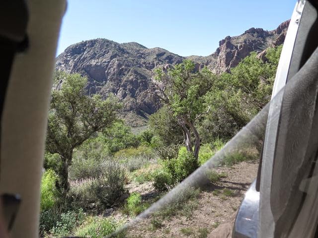
Tuesday 21 April  -  Up early with the morning doves.  (I hear they are tasty).  Also a road runner poking around our site.  Ate breakfast at a desert overlook on the drive back to our original preferred CG and some hiking in the Chisos Mountains Basin area.  Snag an awesome site just as someone else is leaving in the morning.


View out the back window at our new campsite.


Today’s itinerary is a 4 hr (for us) hike from the campground to "The Window" which where all of the water from this high basin exits at a several hundred foot high “pour-over” waterfall.  (However, it being a desert, there is no water, so it’s just a really nice hike through the canyon.)


I leave Val at the trailhead for a few minutes “nature stop” and return to find her mumbling something about a $^!#&;$?  #$%&$!?  BIG snake that just slithered across the entrance to the trail.  Since I wasn’t there to verify, it doesn’t count.

The next encouraging sign (literally) instructs you on how NOT to get eaten by any of the two dozen mountain lions and the occasional bear that inhabit the area.  Essentially it says DO NOT RUN, pick up small pets, look big (???), yell, and throw rocks, (and presumably the aforementioned small pets).  I already knew this so I was prepared with Val’s favorite flavor of bear spray.  Fortunately none of that info, nor the bear spray, was required and we had a quiet, uneventful hike.


Snakes?   Pftttt.  Bring Um On!


NO!  I'm NOT backing up one more step.

End Of Day.   Lots of stars tonight along with a crescent moon right next to Venus??

Good night from Chiso Basin CG.

Brad and Val
=============================================================
This Wasn't The Working One

Wednesday 22 April – Up early and a short run down the road to turn on the generator for toast and coffee.  (No generators allowed in the CG.)  Drive south for about 40 miles to the far south end of the park.  A couple of short hikes along the way.  One to an abandoned homestead in the middle of nowhere.  There was still a working windmill with running water, making a small oasis of shade trees around the adobe estancia foundations.


A little further down the road, a fairly deep wash with some interesting geology and some interesting lizards.  (I'm pretty sure you're going to see LOTS of lizard pictures before this trip is done.)  


Didn’t go very far as there was some overcast and the debris from past flash floods was well up the sides of the walls.

Lunch outside a general store in Castolon, a “town” little changed since the early 1900’s. (Except for the fact that they had Blue Bunny ice cream sandwiches in the little freezer.)


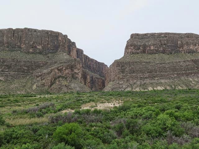
Eight miles further to the goal of the day, Santa Elena Canyon, where the Rio Grande has cut a slot through a massive limestone uplift creating a narrow canyon with 1,200 foot shear walls on both sides.  You can hike a ways into the canyon with the trail ending on sandy beaches before the walls drop straight into the river with no shoreline.  A perfect end to a pretty warm hike.


OK - So Who's Carrying Me Back


Back to Chisos for another night and tomorrow on to El Paso for the start of the next leg of the trip.

Good night again from Chiso Basin

Brad and Val


Sunday, April 19, 2015

Roots

One hundred and thirty-five years ago in 1880, my G-G-Uncle George Davidson and his brother William left the family farm in northern Delaware and set out to find their fortunes in the American West. Along the way, William woo'd and won the love of Blanche, a southern Illinois farm girl, and along she went on the great adventure.  Arriving in Kansas by 1885, the threesome set to work building a business of provisioning the railroad workers opening up track across the prairies.

For reasons unknown, by 1905 they left Kansas for the newly founded southern Oklahoma ranching town of Chattanooga.  This area was in the early stages of homesteading and even though quite remote, hopeful settlers were arriving from points north and east.

William, Blanche and George spent the next 25 years in Chattanooga opening and running a general store where they resided on the second floor.  First George, then William died in 1929 and 1934 respectively and are buried next to each other in Grandfield, a few miles south of Chattanooga.  Blanche relocated to Montana probably glad to be rid of TWO vagabond husbands who dragged her across featureless Kansas then Oklahoma.  (Hopefully Val won't do the same.)  


Only 2-Story Storefont Left In Chattanooga OK
(Pop. @ 400)

Final Resting Place of George and William Davidson
On a small hill overloking Grandfield Oklahoma
(Pop. @  400 before much longer.)
Enough of the history lesson.  This part of Oklahoma is green rolling hills dotted with spring flowers.  Very bucolic.  (Where did that word come from?  Sounds like someone throwing up.)

Anyway, Oklahoma is absolute Eden compared to north Texas.  Pancake flat and covered with scraggly mesquite, this part of rural Texas is pretty harsh, dotted with small dwindling towns with numerous abandoned buildings and homes.  The wellspring of many a country song, to be sure.

Tonight's stop is a nice little state park on a fair sized lake.  Got the place to ourselves almost, and had a nice walk through the cactus garden that is West Texas.


A Desert sprite?
(Or Doctor Pepper?)
Tomorrow to Big Bend.

Goodnight from Lake Colorado City SP, Texas


Saturday, April 18, 2015

Missouri to Oklahoma

No rain last night and no flash flood.  So we were able to get out of the campground at the crack of dawn... (Well it was crack of dawn somewhere.)

Back in the deep dark recesses of this blog, I wrote of our last visit to this campground several years ago.  The morning we left, there was a box turtle in the middle of the entrance road that we rescued.  Well, guess who was back! Right at the same spot.  The next time we come through, he's turtle soup.

Or maybe a hood ornament?
 Also like last time, the road-kill count was exceptionally high.  Mostly armadillos.  No pictures, a little gross.

The rest of the day was not so exciting.  It was Oklahoma after all.  Except for racing the wall cloud to tonight's campground.

We're not in Kansas any more Toto.
"Of course we're not .  We're in Oklahoma  -  Arf Arf"
Good night from ????

Dorothy and the Dog

Friday, April 17, 2015

Day One - Illinois and Missouri

Today was a rolling test of the toys, both electronic and mechanical.  On the electronic side, all appears well with the perpetual tracking system working as intended, (see below).  After a few days I'll be able to tell if we have to mortgage the house to pay Verizon for the bandwidth usage.  

As for the mechanical side, the only issue was a warning that the right rear tire was at 1 psi.  I knew that was a lie because we were still right side up  and not in a ditch.  The rear tires run at a cold pressure of 80 psi.  On a warm day after the tires heat up they'll get up to 95 psi at which time the tire pressure sensor system goes berserk  and tell me they are flat.  Other than that, we're doing good.

On the scenic side, we did pass by the World's Largest Rocking Chair in Cuba MO and a Vacuum Cleaner Museum in St James MO.  Illinois had nothing to compare.

Spending the night at a national forest service CG near Rolla (home of Missouri School of Mines).  Entrance signs warn of flash flood hazard.  Maybe something exciting to report tomorrow.

No pictures.  Conserving that precious bandwidth.


Good night from Lane Spring Campground.


Brad & Val


Monday, April 13, 2015

SPRING HAS SPRUNG!!

Well.....  Sorta anyway.  We have pulled the beast out of hibernation and fed it buckets full of cash so as to be ready for a 9 am 17 April departure on the annual spring trip to ????

Starting back in January we began the planning phase consisting of:

1.   Pick a starting point (Downers grove) ..... and an ending point (also Downers Grove) and feed them them into the mapping software.  (Not much brain-work there.)

2.   Stick a virtual pin into the map at Zion Nat'l Park where Val says, "This time we're staying at least 4 days or I'm flying there without you!"

3.  Stick several more pins in the "must-see before I die" places I've been planning for years.  (Big Bend Nat'l Park, Columbus NM, Canyon of the Ancients Nat'l Monument CO, Burr Trail UT).

4.  Press the GO button and let the software find the best route.

5.   Load in my voluminous collection of out-of-the way, off-beat, and just plain ridiculous things to see in the US.  Then change the "best" route to find as many cool things as possible.


OK  - I admit its probably overkill, but it would be a tragic loss to have driven right by "The World's Largest Pistachio Nut" and not even know its there.  We're not getting any younger, ya know?

Anyway, three months later, after pouring over almost 300,000 square miles of Google Earth aerials and USGS Topo maps, we (I) have tentatively settled on a route and timetable that hopefully will keep us from roasting in the Chihuahuan Desert of south Texas, or needing snowshoes in some of the high country of Utah.


The 1st leg is pretty much a bee-line to Big Bend National Park Texas, with possible short stops at the Marlin Perkins Statue in Carthage MO, The International Linen Registry in Tulsa, the Route 66 Shoe Tree in Stroud OK, World's Smallest Skyscraper in Wichita Falls, National Wasp (bug, or white anglo...?) Museum in Sweetwater TX, (etc. etc. etc.).  Then stopping in Big Bend for 3 days.


From Big Bend we make our way to Zion Nat'l Park by way of, (depending on weather forecasts), south New Mexico, then up through the middle of Arizona and into south Utah.

The only locked in dates are Sedona and Zion for 3 days each.  After Zion, we are free-range-chickens and plan to zig-zag back and forth, (redundant?), across southern Utah and Colorado with a focus on early native American and more recent western history sites, and of course general scenery.

As usual, I have a stable of "toys" including 2 active cell phones, 2 dead ones (still GPS capable), two laptops, a tablet (maybe two), a mobile hot spot, and the on-board GPS.  That's NINE gps devices.  A RECORD!!  No satellite dish yet, but I did get an new sat-phone (texting only) which will also drop a bread-crumb every 10 minutes on the live map below EVEN without cell coverage.  I'm still experimenting with this, so we'll see......

More to come when we're actually On the Road Again

Brad & Val


Tuesday, August 12, 2014

The Long Way Home

Since the last post, we've been on a long run back from Skagway (A) down the Cassier Highway (C-B) to Hyder AK (B),through central BC, to Mt Baker in Washington (D), and then to Portland (E) for Jessica's birthday (a "few" days late). 

Note - OK, I know the letter sequence is out of wack, but we've been wandering around for almost two months so cut me some slack.


As usual on the return run, I'm getting lazy and forgoing the running commentary, (much to the reader's relief).  Below are the highlights.

Haines Highway AK & Yukon

RR built in 1900 and still carrying passengers,
(but not me)

I think they forgot something??


Just another pretty mountain.

A jade mine on the Cassiar Highway.  The bolder
is a solid hunk of jade,

It MIGHT be jade!
(But it will look good in the garden anyway.)

Now this is a decent RV park.

This is a walk from the above RV Park


ANOTHER pretty mountain.


Road grizzly on the way to Hyder AK
Road to Hyder AK

Hyder grizzly fishing.
(Below too.)


They're friendly.

Waterfalls from glacier about 2,000 ft above us.

Mt Baker Washington.
(World record annual snowfall of 1,137 inches in one season.)


Made it to Portland for J's B-Day
 Going camping for a week or so with Jess and Scott then Who Knows?

Good night from Portland

Brad & Val