[BD]
The original plan upon departure from Chaco (A on map) Wednesday was to head back south to Cuba (New Mexico) and up into the mountains east of Los Alamos. However, since Chaco had no shower facilities, and we had been 3 days without, we felt it was stretching the relationship a bit to go without for much longer.
So it was north instead to Bloomfield NM (B on map), laundry, a shower and another excellent Mexican restaurant. Carne Avado (shredded pork) with a sopapilla which I've never had before. I would describe it as a large flat Crispy Creme, (the sopapilla, not the shredded pork). Very tasty and surely good for my cholesterol levels.
Bloomfield is an interesting little energy boom-town. Lots of oil and natural gas, red dust, roughnecks and hard lookin' women, but all blended together in a pleasant sort of way. Everyone with a lot of wrinkles and a smile.
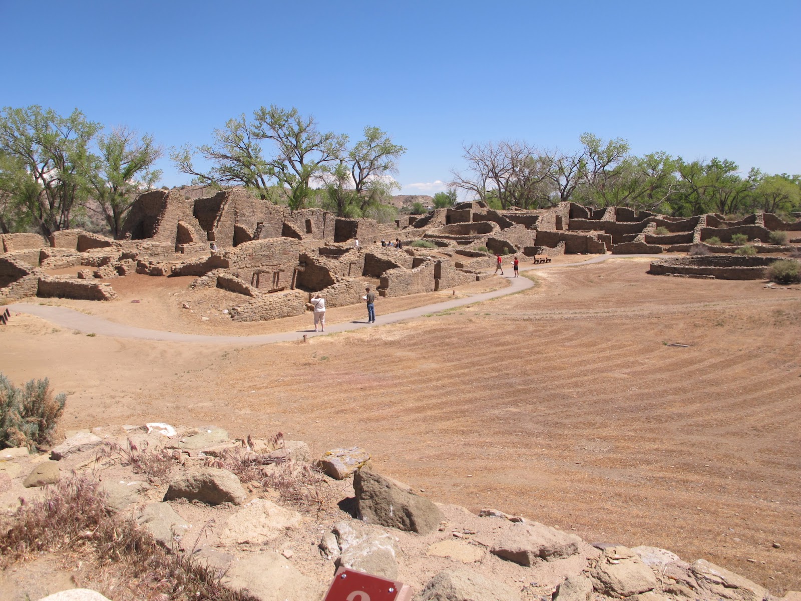
 Thursday 10 May - From Bloomfield, north a short way to Aztec Ruins (C on map). (They're in the town of Aztec, not built by Aztecs.). A branch of the same group as Chaco and a similar architectural style. The big difference here being that the National Park Service mission is educational rather than spiritual like Chaco.

With portions of the first floor of the 2-3 story structure intact, you could get a good sense of what the inside living conditions would be like.Wandering through the labyrinth of passages was definitely cool.
A Note For the Ya-Ya's

 After crawling around the ruins, it's Eastward to Heron Lake (D on map). A large state park centered on a reservoir with a focus on fishing. We selected a campground with about 30 sites and since we were the only ones there, we had the best site overlooking the lake at sunset.
Friday 11 May - Having completely blown the itinerary (such as it was) by heading north rather than south after Chaco, we wake up not knowing what to do next. So we just stay in bed and look at the lake. Eventually we get up and head for a hike down to the Chama River.
Now the laws of geography dictate that in a round trip hike, the vertical distance down into the canyon will be equal to the vertical distance back up to the Funmobile. Well.... That's a load of "elodes armati" (the afor-mentioned armored stink beetles). It's at least twice the vertical distance back up.


A good hike never-the-less with a really cool swinging bridge down at the bottom. Val REALLY likes swinging bridges, especially when I make them REALLY swing. (Some things guys never grow out of.)

Then we turn south again with a goal of Kasha-Katuwe, (God Bless You). Drove for about an hour and stopped for lunch at Echo Amphitheater (E on map) just north of ????. Even though it was only 60 miles from where we started the day, it was so pretty we decided to stay the rest of the day and camp there for the night. Again only one other camper.

If the weather clears, tomorrow should be another spectacular sunrise on the high canyon walls behind the campsite.
Good Night from ?????.
Brad & Val
 |
| Broken Compass |
The original plan upon departure from Chaco (A on map) Wednesday was to head back south to Cuba (New Mexico) and up into the mountains east of Los Alamos. However, since Chaco had no shower facilities, and we had been 3 days without, we felt it was stretching the relationship a bit to go without for much longer.
So it was north instead to Bloomfield NM (B on map), laundry, a shower and another excellent Mexican restaurant. Carne Avado (shredded pork) with a sopapilla which I've never had before. I would describe it as a large flat Crispy Creme, (the sopapilla, not the shredded pork). Very tasty and surely good for my cholesterol levels.
Bloomfield is an interesting little energy boom-town. Lots of oil and natural gas, red dust, roughnecks and hard lookin' women, but all blended together in a pleasant sort of way. Everyone with a lot of wrinkles and a smile.
 Thursday 10 May - From Bloomfield, north a short way to Aztec Ruins (C on map). (They're in the town of Aztec, not built by Aztecs.). A branch of the same group as Chaco and a similar architectural style. The big difference here being that the National Park Service mission is educational rather than spiritual like Chaco.
 |
| HAH!! - And you snicker at my GPS |

With portions of the first floor of the 2-3 story structure intact, you could get a good sense of what the inside living conditions would be like.Wandering through the labyrinth of passages was definitely cool.
A Note For the Ya-Ya's

 |
| Those Pueblo things ain't all that tough. |
 After crawling around the ruins, it's Eastward to Heron Lake (D on map). A large state park centered on a reservoir with a focus on fishing. We selected a campground with about 30 sites and since we were the only ones there, we had the best site overlooking the lake at sunset.
 Friday 11 May - Having completely blown the itinerary (such as it was) by heading north rather than south after Chaco, we wake up not knowing what to do next. So we just stay in bed and look at the lake. Eventually we get up and head for a hike down to the Chama River.
 |
| DOWN |
 |
| UP |
Now the laws of geography dictate that in a round trip hike, the vertical distance down into the canyon will be equal to the vertical distance back up to the Funmobile. Well.... That's a load of "elodes armati" (the afor-mentioned armored stink beetles). It's at least twice the vertical distance back up.


A good hike never-the-less with a really cool swinging bridge down at the bottom. Val REALLY likes swinging bridges, especially when I make them REALLY swing. (Some things guys never grow out of.)

Then we turn south again with a goal of Kasha-Katuwe, (God Bless You). Drove for about an hour and stopped for lunch at Echo Amphitheater (E on map) just north of ????. Even though it was only 60 miles from where we started the day, it was so pretty we decided to stay the rest of the day and camp there for the night. Again only one other camper.

If the weather clears, tomorrow should be another spectacular sunrise on the high canyon walls behind the campsite.
Good Night from ?????.
Brad & Val
No comments:
Post a Comment