Saturday 25 April
- Scrapped today’s original plan
in favor of something we saw on the way to the campground last night. Those of you who are “mature” enough to
remember the TV series “Broken Arrow” know that it was the sanitized story of the
famed Chiricahua Indian Chief Cochise, and Tom Jeffords, the local Agent who was the
intermediary between Indian Tribe and US Government. What you probably don’t know is that much of
the story took place (in real life) at Fort Bowie Arizona, (and no, none of my relatives were there), about 30 miles from
our last night's campground.
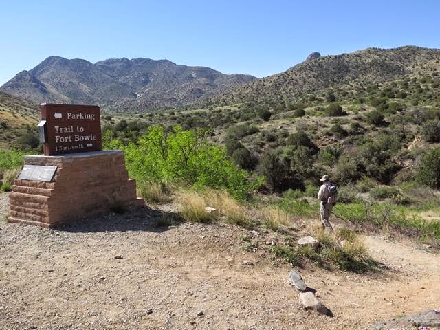
So today, we’re headed to Fort Bowie National Historical
Site. The trailhead to the site is a
scenic 10 mile drive up the dirt Apache Pass Road into the Chiricahua
Mountains.

From there it is a short 1.5
mile hike up through hilly Arizona desert country to the remains of what was a
large Army Post located in a high isolated valley.

The back story is that in the 1861 Cochise was
believed to have been involved in a wagon train massacre and the kidnapping of
a small boy from near this location. He
was arrested by the Army and escaped, but 6 others of his band were summarily
executed. This was the start of a
10-year war for control of Apache Pass, through which the famed cross-country
Butterfield Stage Road ran, and in which existed the only natural spring in the
area. (It was later proved that another band was actually responsible for the
massacre.)
The trail first takes you up the valley past the ruins of
the stage station and the faint track of the stagecoach road, the primary
purpose of the fort being to protect immigrants passing along that route.

A bit further along is the cemetery where those who perished
in the pass from natural or (more often) unnatural causes, were interred. Many headstones were simply marked “Killed by
Indians”, names lost forever to history and to loved ones.

As we near the site of the fort, we pass Apache
Springs. The small trickle of water
flowing over a rock ledge must have looked like the fountain of youth to any
passersby of that early era. Even after
the short distance we’d hiked so far, it was an inviting sight.

Above, on top of a small hill overlooking the spring, stands
a low stone wall where the first defenders of the spring set up camp prior to the
building of the more substantial post a year later. It would have been a pretty
miserable place, completely open to the elements, as well as to fire from those
who owned the hill before.
Just up the trail from the spring is the foundation of the “Agency Building” occupied by Tom Jeffords during a later period when an uneasy peace replaced the long violent conflict. (Probably the time-frame of the TV show.)
By this point we (I anyway) are immersed in the story and
the place. Nothing is physically changed
from 150 years earlier when the next breath you took may have been your last.

At the end of the trail, is Fort Bowie. A large American flag raised above the parade
grounds surrounded by 40 or 50 acres of what would be barracks, corrals, store
houses, officers quarters, a hospital and even a tennis court. The fort in its prime was very large and
would have been home to several hundred troops as well as some of their
dependents and other civilians. After
its abandonment in 1894, what remains is only adobe walls and foundations. But it takes little imagination to picture
what would have been a busy frontier military community.


On the recommendation of the resident ranger, we take a
different return route up a steep rocky trail to a ridge overlooking the entire
valley. There is a forest of bright red flowered ocotillo on an otherwise drab
hilltop, and the “brisk” 30 plus mph wind is actually welcomed, canceling out
the rising afternoon temperatures.


For anyone who is a history buff, I’d highly recommend this
as one of the best sites I’ve visited over the years. Although the fort site is fairly small, it is
tucked into a corner of a huge and beautiful landscape that was critical to
development (good and bad) of the American West.
By now late afternoon, we head for Catalina State Park,
north of Tuscon (with a stop at Olive Garden).
So Goodnight From Tuscon
Brad and Val
Thanks for the walk through history. Even if Cousin Higby wasn't there.
ReplyDelete